CURRENT NASA-JPL MISSIONS
COSMIC and COSMIC-2
The Constellation Observing System for Meteorology, Ionosphere and Climate (COSMIC), is a joint U.S.-Taiwan project launched in April, 2006. It consists of six spacecrafts and each one carries the Integrated GPS Occultation receiver (IGOR) designed at JPL. With its high inclination (72o) orbit the constellation was able to capture 2000-2500 occultations per day globally. COSMIC was retired in May, 2020 after 14 years of operation.
Due to the success of the COSMIC mission, U.S. and Taiwan moved forward with a follow-on GNSS-RO mission called FORMOSAT-7/COSMIC-2 (COSMIC-2). The COSMIC-2 constellation also consists of six satellites that were launched successfully in June, 2019 into low-inclination (24o) orbits. The GNSS-RO receiver payload, named TGRS for Tri-GNSS Radio-occultation System, was developed by NASA-JPL. By collecting data with a low-loss beam former and the “cafeteria cups antenna”, COSMIC-2 is able to track more than 4,000 high-quality profiles per day. COSMIC-2 also includes two space weather science payloads: a Radio Frequency Beacon (RFB) transmitter and an Ion Velocity Meter (IVM). The number of RO atmospheric and ionospheric observations has been increased significantly since the launch of the COSMIC-2 mission and greatly benefits the scientific research and operational communities.
The execution of COSMIC-2 program was led by NOAA, USAF, NSPO from Taiwan, and UCAR. Taiwan contributes with the constellation and a satellite operations control center. Data Analysis and Archiving is provided by the UCAR CDAAC in Boulder, Colorado. A global fiducial network built upon existing NASA and international fiducial networks is also part of the project. The project scientist for the US side of the partnership is C. Rocken from UCAR. JPL is also a processing center for COSMIC-2 data.
More information:
NOAA: https://www.nesdis.noaa.gov/OPPA/cosmic2.php
UCAR: https://www.cosmic.ucar.edu/what-we-do/cosmic-2/
NSPO: https://www.nspo.narl.org.tw/inprogress.php?c=20022301&ln=en
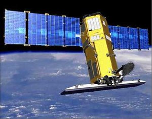
GRACE AND GRACE FO
The Gravity Recovery and Climate Experiment (GRACE) was launched in March of 2002 and consists of 2 identical spacecraft flying about 220 km apart in a polar orbit around 500 km above the Earth. The primary mission is to make measurements of the time varying gravity field of the Earth. Each spacecraft carries a Blackjack GPS receiver that, in addition, acquires GPS occultation measurements. One receiver's antenna points in the fore direction while the other points in the aft direction. Each receiver was able to capture about 200-250 occultations per day before the end of the mission in March, 2018.
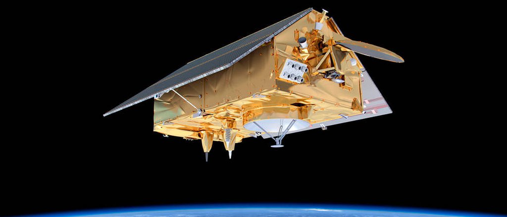
The successor of the GRACE mission, GRACE Follow-On (GRACE-FO), was launched in May, 2018 aboard a SpaceX Falcon 9 rocket. While its orbit and design are similar to the ones of the previous mission, GRACE-FO employs the Laser-Ranging Interferometry (LRI) technical experiment, which can enhance the precision of distance measurements by a factor of 20. Both satellites are equipped with Tri-GNSS Radio-occultation receiver developed by JPL to provide more than 200 atmospheric profiles per day.
The project is an international collaboration sponsored by NASA and the Deutsche Forschungsanstalt für Luft und Raumfahrt (DLR). The Principal investigator is Dr. Byron Tapley from the University of Texas Center for Space Research (UTCSR), and the Co-Principal Investigator is Dr. Christoph Reigber from GFZ. The project management and systems engineering activities are carried out by JPL. Atmospheric profiling will be performed at the two main centers, JPL and GFZ.
More information:
NASA: https://www.nasa.gov/mission_pages/Grace/index.html
NASA-JPL: https://gracefo.jpl.nasa.gov
GFZ: https://www.gfz-potsdam.de/en/grace/
DLR: https://www.dlr.de/rd/en/desktopdefault.aspx/tabid-2440/3586_read-5326/
PAZ ROHP
The Spanish Earth Observation PAZ satellite was launched in Feb, 2018. Its primary payload is a Synthetic Aperture Radar (SAR) but the mission includes an advanced Integrated GPS Occultation receiver (IGOR+) developed by JPL for atmosphere observing purposes. PAZ has a sun-synchronized orbit with high inclination angle (97.4o) and 514 km nominal height, which is also the same orbit shared with TerraSAR-X and TanDEM-X. The RO receiver onboard can collect more than 200 occultations per day.
The IGOR+ payload onboard PAZ spacecraft conducts a proof-of-concept experiment: Radio Occultation and Heavy Precipitation (ROHP). This is the first time GNSS-RO measurements are taken at two orthogonal polarizations to assess the capability of detecting and quantifying the heavy precipitation along the RO ray path. This new application of RO, called polarimetric RO (PRO), could help understand the thermodynamic conditions during intense precipitation by providing high vertical resolution profiles of temperature, moisture, and precipitation, simultaneously.
The ROHP-PAZ experiment is a joint effort between the Institute of Space Sciences (ICE) and the company HISDESAT. The Principal investigator is Dr. Estel Cardellach from ICE, which is an Institute of the Spanish National Research Council (CSIC) and a unit of the Institute for Space Studies of Catalonia (IEEC). The RO data processing is operated by NOAA with the participation of UCAR. JPL also collaborates with the ROHP-PAZ international scientific team for PRO applications and research.
More information:
ESA: https://earth.esa.int/eogateway/missions/paz
HISDESAT: https://www.hisdesat.es/en/paz/
CSIC-ICE: https://paz.ice.csic.es/index.php?idi=EN
KOMPSAT-5
The Korea Aerospace Research Institute (KARI) developed and manages the Fifth Korea Multi-Purpose Satellite (KOMPSAT-5) system, whose primary payload is the X-band synthetic aperture radar (SAR) for multi-mode observations. KOMPSAT-5 was launched on 22 August 2013 in a sun-synchronous near-circular high-inclination (97.6o) orbit at an altitude of 550 km. The science objectives include the acquisition of independent high-resolution SAR images in all weather for GIS applications; surveying natural resources for Ocean and Land management, and surveying large-scale disasters for Disaster and ENvironmental monitoring applications (GOLDEN mission).
KOMPSAT-5 also carries a secondary payload. KASI (Korea Astronomy and Space Science Institute) developed and manages the Atmospheric Occultation and Precision Orbit Determination (AOPOD) payload, which includes a dual frequency GPS receiver (IGOR) designed at JPL and a laser retro reflector array (LRRA).
The Integrated GPS Occultation Receiver (IGOR) instrument was provided by Broad Reach Engineering and was based on the Blackjack GPS receiver developed at NASA’s Jet Propulsion Laboratory (JPL) and flown on multiple missions. The IGOR receiver has four input antennas (two POD antennas and two occultation antennas) with 0.1 Hz and 50 Hz sampling rates for precise orbit determination (POD) and atmospheric radio occultation (RO) observations, respectively. KOMPSAT-5 is currently flying and has been providing (on average) hundreds of neutral atmosphere occultation soundings daily since 2015, from the lower to the middle stratosphere, globally and for all weather conditions.
More information:
KARI: https://www.kari.re.kr/eng/sub03_02_01.do
TERRASAR-X AND TANDEM-X
TerraSAR-X, a radar Earth observation satellite, is a joint venture being carried out under a public-private-partnership between the German Aerospace Center (DLR) and AIRBUS Defense and Geo-intelligence (formerly EADS Astrium). The exclusive commercial exploitation rights are held by the geo-information service provider AIRBUS. TerraSAR-X was launched on June 15, 2007 and has been in operational service since January 2008. With its twin satellite TanDEM-X, launched on June 21, 2010, TerraSAR-X acquires the data basis for the WorldDEM, the worldwide and homogeneous DEM available from 2014.
Both TerraSAR-X and TanDEM-X are in sun-synchronous dusk-dawn orbits with 97.4o inclination and 514 km height. The JPL-developed IGOR receiver is carried as the secondary payload to collect more than 200 occultations per day for each satellite. The data collocation, assimilation, and the related tracking, occultation, and ranging (TOR) experiment is conducted by GFZ.
More information:
ESA: https://earth.esa.int/eogateway/missions/terrasar-x-and-tandem-x
Airbus: https://www.intelligence-airbusds.com/en/228-terrasar-x-technical-documents
PAST MISSIONS
IOX
IOX is part of the experimental payload of the PICOSat satellite which is part of the Department of Defense (DoD) Space Test Program (STP) executed by the Air Force. PICOSat is a microsatellite built by Surrey Satellite Technology Ltd (SSTL) in Guildford, UK and partially funded through the DoD Foreign Comparative Testing Program. PICOSat was launched on the NASA Kodiak Star mission on 29 Sept 2001 from the Alaskan Spaceport in Kodiak, AK.
The Ionospheric Occultation Experiment (IOX), with Paul Straus of Aerospace Corp. as the principal investigator, has been developed by the USAF Space and Missile Systems Center. It uses a space based dual frequency GPS receiver to measure ionospheric properties. IOX demonstrates remote sensing techniques for future DoD space system and improves operational models for ionospheric and thermospheric forecasts. JPL was a processing center for IOX data.
SUNSAT
On February 23rd 1999, the first South African satellite was launched aboard a Delta II Launch Vehicle. SUNSAT was a micro-satellite built by post-graduate engineering students in the Electronic Systems Laboratory, from the Department of Electrical and Electronic Engineering at the University of Stellenbosch. It carried a Turborogue GPS receiver for POD and occultations. Despite the success of the mission as a whole and constant efforts to obtain radio-occultations, continuous tracking of GPS satellites was never possible for times long enough to obtain reliable orbit solutions needed for occultation retrievals.
OERSTED
Ørsted was launched on February 23rd 1999 aboard the same rocket as SUNSAT, and was managed by the Danmarks Meteorologiske Institut. The Danish PI of the occultation experiment was Per Høeg. Ørsted carried a Turbo-Rogue GPS receiver built at the Jet Propulsion Laboratory in California and paid for by NASA. The purpose was to accurately determine the position of the satellite. This instrument was used periodically to track radio-occultations.
The receiver prototype was a model identical to the one aboard SUNSAT. However, data coverage was sufficiently continuous for orbit purposes, which enabled a precise orbit determination as is required for processing occultations. As a result, some hundred occultations were successfully retrieved during the life of the experiment. One of the 2 GPS frequencies was measured with a very low SNR, which motivated a study on the capabilities of doing single frequency occultation retrievals.
GPS-MET
The GPS radio occultation technique was tested for the first time with the launch of the GPS/MET mission from April 3, 1995 to March 1997. GPS/MET was an experiment managed by the University Corporation of Atmospheric Research (UCAR) (Ware et al., 1995) and consisted of a 2 kg GPS receiver piggybacked on the MicroLab I satellite which had a circular orbit of 730 km altitude and 60 degree inclination. The GPS receiver was a space-qualified TurboRogue (Meehan et al., 1992) capable of tracking up to 8 GPS satellites simultaneously at both frequencies transmitted by GPS. Under an optimal mode of operation, the GPS receiving antenna boresight was pointed in the negative velocity direction of the LEO providing 100-150 globally distributed setting occultations per day. Tens of thousands of occultations were collected and were used to assess the accuracy and potential benefit of the GPS radio occultations.
Under ideal conditions, when a LEO tracking GPS has a 360 degree field of view of the Earth's horizon, about 750 occultations per LEO per day can be obtained. However, side-looking occultations (GPS-LEO link > 30 degree from velocity or anti-velocity of LEO) sweep across a large horizontal region, and the spherical symmetry assumption used in the Abel inversion becomes inaccurate. Discarding side-looking occultations, one LEO provides up to 500 occultations per day. GPS/MET however tracked only setting occultations using an aft-looking antenna, which reduced the maximum number of occultations to 250 per day. Moreover, due to limited on-board memory and insufficient coverage from ground GPS stations (required for calibrating the GPS satellites' clocks), the maximum number of occultations obtained from GPS/MET varied between 100-150 occultations per day.
CHAMP
In 2000, the German satellite CHAMP was launched carrying a new generation of GPS receivers, the "Blackjack", developed at JPL. The mission was managed by the Geophysikalisches Forschungszentrum (GFZ) at Potsdam (Germany), which was the other main data processing center of CHAMP radio occultations. The CHAMP Blackjack started collecting atmospheric profiles on April 6, 2001 and since then collected up to 250 daily occultations during much of 2001. This receiver had enhanced capabilities over the older generation GPS/MET instrument, which include "enhanced codeless" tracking (i.e., the ability to track the encrypted GPS signals), higher signal-to-noise ratio, and lower tracking in the atmosphere. The Blackjack GPS receiver captured high vertical resolution profiles over land and oceans and provided data complementary to other sounding techniques.
SACC-C
In 2000, the Argentinian satellite SAC-C was launched carrying a new generation of GPS receivers, the "Blackjack", developed at JPL. The mission was managed by the Argentinian CONAE, which was the other main data processing center for SAC-C occultations. On July 7th. the SAC-C Blackjack captured its first profile and since then collected up to 250 daily occultations during much of 2001. This receiver had enhanced capabilities over the older generation GPS/MET instrument, which include "enhanced codeless" tracking (i.e., the ability to track the encrypted GPS signals), higher signal-to-noise ratio, and lower tracking in the atmosphere. The Blackjack GPS receiver captured high vertical resolution profiles over land and oceans and provided data complementary to other sounding techniques.